| Willapa / Naselle River Sturgeon Fishing |
|
Launches :
There are
actually at least 8 launches that can be used in the Willapa Bay.
However the 4 listed below are are probably
the ones most sturgeon fishermen are concerned about using.
(1) South
Bend, city of South Bend
(2) Raymond
City Park
(not recommended for low
tides, as it is shallow and MUDDY)
(3) Old
Willapa / Wilson Creek WDFW
(4) Long
Island, Willapa National Wildlife Refuge
The South Bend Launch : This launch as been rebuilt the summer of 2004, with an extra wide single lane poured corrugated concrete ramp with a spot or two of parking for handicapped.
The City of South Bend has revised it's boat launch and dock ordinance the
spring of 2007. There is now a $5 maintenance fee for launching at the
ramp. That maintenance fee includes one day's parking in the launch area.
One day is defined as 00:01 to 24:00. If parking multiple days, a $5 fee
is due each calendar day. Unattended vehicles without trailers are also
assessed a $5 fee. If you have buddies, with their vehicles, it is
suggested to have them park downtown and pick them up at the main dock.
The city is also in the process (2007) of expanding the parking area some and a
grant request is in process to expand it even more. Rules and copy of
ordinance (1365) are posted at the launch area.
This launch is located on the main Highway 101 just West of the town of South Bend. The main parking lot is just past the launch northwest of the main launch area.
It is a good ramp for boats up into the 20'+ class. Even the 30' gillnet boats launch here. The ramp is is angled out and downstream with a dock on the downstream side. A loading/unloading float as been added early 2007 off the end of the main launching dock. The concrete ramp goes to just below the end of the dock with heavy gravel below the concrete that is angled down at about twice the ramp angle. I also like the barber poles at the top of the ramp to guide you back until you can see the ramp itself.
Launching from this ramp will put you into the upper fishing area rather soon, as you will be running downriver and can be fishing at the big bend seen to the left in the picture within 1 mile. The distance by water from this launch to Tokeland is about 8 miles. However you will be fishing about 3 to 4 miles upriver from Tokeland. It is a lot faster to run the distance to the fishing area by water if you are coming in from Highway 6 at Raymond, than it is to drive around to the Tokeland launch, and then run out into the same fishing area of the river that you had driven by.
In the past during the prime time for fall salmon on week-ends, the parking lots can fill up, so the improvement to the parking will be helpful.
Launching from this ramp will put you into the middle of most of the fishing area rather soon.
What to Use & Methods : Most bay / river fishermen here will probably use sand shrimp over smelt or herring.
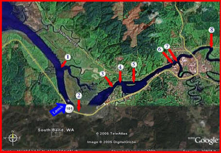
Where to Fish : We will start with the main fishery in the Willapa itself. The numbers reflected here refer to the corresponding numbers on the map below.
(#1) There are favorite fishing holes downstream from the South Bend (the blue arrow) launch in the first big bend.
(#2) Upriver near the upper end of the docks in South Bend seems to also be a favorite location.
(#3) Then upriver farther there is a 40' hole, and
(#4) slightly farther up under the power lines at the upper end of the 40' hole is another spot.
(#5) We have also seen fishermen in shallower water at the upper end of the island.
(#6) Farther upriver off the old Weyerhaeuser docks, you will many times see vehicles parked on these docks with rods out. This area seems to also be a good spot.
(#7) And slightly farther near the Weyerhaeuser mill at the confluence of the South Fork of the Willapa is another hole.
| The new South Bend launch addition 2007, looking downriver | Some known sturgeon fishing locations on the Willapa |
|
|
 |
Willapa River above Raymond : I suggest running from the South Bend launch upriver above the bridge if you plan on fishing #8 because of the condition of the Raymond City Park launch. If you DO use the Raymond launch, you just run downstream a few hundred yards to the first large bend there is the hole (8) described previously where many bankies and boaters frequent. The bankies will access it thru the Weyerhaeuser log scaling gate and keep to the right to where the road is on top of the dike. This road goes all the way to the inside corner of this bend, where they set up camp.
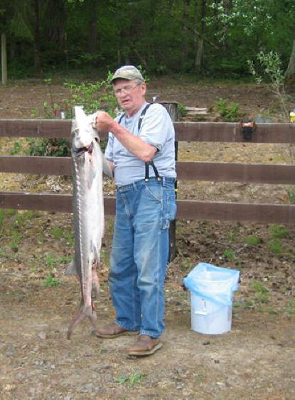
| Another 1/4" longer & he would have had to throw it back |
 |
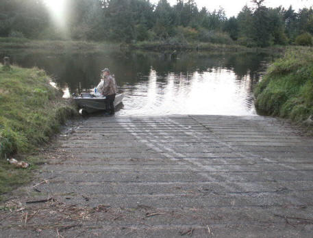
Raymond City Park Launch : This launch is not used much as shown from this picture for obvious reasons. The rumor is that it was supposed to be dredged, but nothing yet after about 15 years that I can recall. So it is basically a mid to high tide launch unless you plan on staying out for a while.
This launch is reached off Hiway 105 just as you exit Raymond, heading north toward Aberdeen. Take the last street to the right just before the bridge, go past the Weyerhaeuser scale yard and the Pacific Pride refueling station. Straight ahead is the city park, with baseball diamonds etc. To the left there is a gravel parking lot along with a skateboard ramp area. At the far end of the parking lot is restrooms and the launch/docks. It is a shame that the city has chosen to not make any improvements as for dredging the short section from the river into the dock area. This park is has been kept up for youth type sports, but the fishermen's needs have been abandoned.
Wilson Creek Launch :
The farthest
upriver launch is this one, it is reached by turning off Highway 6 just
east of the old WDOT weigh station about a
mile before you get to the hill east of Raymond. Heading west on Highway 6, take a right just
before this unmanned weigh station, cross thru the next intersection, which Camp
One Rd. This intersection is a lazy X. Cross it and take the
Armstrong Rd. heading north a short distance to where it tees into the Willapa Rd. , take a right
there. This will
take you up the river, across the Willapa River bridge (#2 on the map below),
thru the small community of Old Willapa and then across the
low concrete bridge at Wilson Creek. An immediate left turn just past the Wilson Creek bridge
will put you into the launch parking lot. The launch is on the main
Willapa River with Wilson creek bordering the upstream side of the parking area.
This area is not fished that much for sturgeon, but there is one hole below the launch on the bend that I have seen big fish on the depthfinder that I assumed were sturgeon.
| Wilson Creek launch at near a high tide |
 |
Naselle River : The Naselle can produce
sturgeon also, the
closest launch in tidewater is the Long Island Game Refuge ramp. This is
a no charge gravel launch wide enough for 2 boats, no dock but parking is
across the road by the office. Launch here. then head north, staying close to
the piling markers on the east side of the channel most of the way out, as this
channel is also narrow, shallow and is covered with oyster beds. I have
however navigated it (my first time there) with a 20' fiberglass deep Vee at a 0' tide. You
can make it if you go slow and are willing to back up and try another spot
until you learn the channel.
| Long Island, National Wildlife Refuge boat launch & dock | Long Island, National Wildlife Refuge boat launch |
|
|
|
You may only have 3' of water under you at
times. When the piling markers on the right side of the channel cease and you
get to where the channel opens up, you will see a clay bank bluff on the
western shore of Long Island ahead of you, head angling across the channel toward this bluff,
then follow this shore until you come out into the mouth of Long Island and
Stanley Peninsula where you take a right at the piling marker to the east
and head up the
main Naselle River.
| A keeper in the boat |
|
|
There is sturgeon fishing spots from where you enter the main river here
all the way up and under the Highway 101 bridge, then farther up to where you can see the
Y in the highway going to Raymond. And clear up into the bend above that
has been good at times.
There is also a small gravel launch on the East side of the Highway Southwest
of the town of Naselle that is good for only smaller sleds or drift boats. This
is also a river that can be fished like the upriver Willapa.
Here the sturgeon fishing will usually be done from where the Long Island channel meets the main Naselle River upriver to above the Hiway 101 bridge upwards toward the town of Naselle.
Copyright © 2004 - 2020 LeeRoy Wisner All Rights Reserved
Back to The Main Ramblings
Page
Originated 4-13-2004 Last
updated 11-23-2020
***
to
contact the author click here