 |
Cowlitz River Boat Launches |
 |
Boat launches of the Cowlitz starting at the mouth of the
river and going upriver.
Gearhart Gardens :
Take exit 36 off I-5, cross over the Cowlitz River bridge, then take the immediate
right to
Gearhart Garden Road and boat ramp. There are 2 parking lots, the first
one was where the old abandoned ramp was, so go straight ahead to the second
northern
lot. If the tide is out the word is to immediately head for the far
shore and follow it to lessen your chances of running aground.
Carnival Market : The Carnival Market LAUNCH is about 3 miles up Westside Highway from Longview. This is the highway that runs north/south on the West side of the river. Look for a market that looks like a big Circus tent on the west side of the highway with a big pullout on the east at the riverside.
You could use this IF you have 4 wheel drive AND GOOD KNOBBY TIRES, or if it is a small Jon boat, then do it by hand. As seen in the photo below, the upper part is not that steep but WITH 2 DEEP ruts and VERY PRIMATIVE. The lower more sandy section at the waters edge IS STEEP. This sand is the dark gray Mt. St. Helens ash. Then depending on the river height you have more sand if it is running low during the summer months. And I remind you again, steep for anything but a small boat to recover, unless you have a buddy with a 4 X 4 and a winch standing by. I have seen drift boat launch/recovery sites better than this. This pickup and trailer shown here would be minimal. Getting down would not be the problem, but getting a boat of any size back up may well be a problem as it get WORSE on the lower end.
| Cowlitz River Carnival Market launch |
|
|
I stopped by later, August 1st, and the water had dropped about 4' below the photo shown here. Anything other than a car-topper would have likely had problems navigating out into mid channel as it had an exposed sandbar about 1/3rd of the way out in the channel and we could see bottom in most places out to that sandbar.
Camelot :
Camelot launch is a beach
launch, again off the Westside
Highway. Accessible from either Castle Rock or Longview. Coming from Longview, head North approximately 5-6 miles. The road turning in to it is Camelot Drive
to the east and goes down into and through a mobile home park. Coming from Castle Rock
turn south on the Westside
Highway at Four Corners store, go about a mile to Camelot Drive on the left. Go
straight ahead to a stop sign, straight thru it and downhill past the end of the County maintained road sign. From
here you drop down onto part of the old Mt St. Helens lava gravel bar removal area. Head to
the right, there are a couple of tie-in roads to the beach. At low water the deepest access is on the upper section
of this beach, later the
water is deep enough to launch about anywhere on the beach.
This is a long gravel bar on the west side that gives an inside corner for a long ways and can also be bank fished. The bar runs out and upstream. Plunkers will fish the bank south of these photos and bankies will be on the east bank from the railroad tracks. Boaters like to fish this east shore deeper water. This is one place where a small prop boat can launch and fish downstream without encountering gravel bars UNLESS the river is real low.
I have inquired and it is my understanding that most of this property is owned by Cowlitz County, I contacted the Cowlitz County parks Dept and they referred me to DNR. I have tried to get ahold of DNR and get no response, therefore I can not find anyone who will give me a definitive answer. However some say this requires the state Discovery pass if you intend to use it or you will be ticketed, I am not so sure about this as it seems to be pretty much a No Mans Land.
| Deepest part of Camelot launch area when this photo was taken is where this boat just launched | Here they are launching on the gravel bar at about the location of where the photo on the left was taken |
|
|
|
Hog Island :
Apparently
this once used access has been barricaded off & is now unusable
However at this highway pullout, if you continue north along the narrow access
road you will come to a unimproved boat launching area (notice I did not call it
a boat ramp) at the tail of a large pool just before the divide that went to the
old Hog Island ramp. The launch is somewhat protected from the river current
by the bank cuts.
It is really only a 4 wheel drive show for more of a drift boat launch/recovery
location. Very unimproved, narrow access, no gravel and deep muddy ruts to
the water. Just above it is a well known plunking hole.
North on Westside Hwy 5.7 mile the access site is on east side of Rd.
Castle Rock :
As per a newspaper article 6-20-09 the city of Castle Rock was installing a
2 lane boat ramp on the river above the bridge and accessible from the Westside Highway behind the high school before August of 2009. This launch is
now functional 2-2010. Coming from the south after you cross the
Castle Rock bridge, take the right at 4 corners and then another right just
before you get to the high school. There is a high overhead entrance sign
over this road. The access road goes past the south
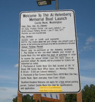
side of the ball field and east toward the river. There is a pay booth at the
head of the ramp with a fee of $5.00.
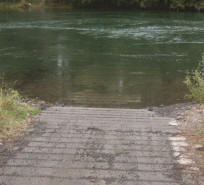
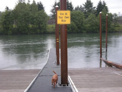
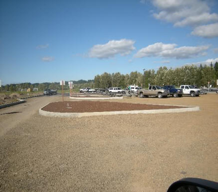
There is a wide two lane long slightly steep ramp. The parking is close but if during a busy fall week-end, it fills up fast even though it has lots of parking. So if a lone fisherman has to launch his boat, tie it to the back side of the lower dock, drive the towing vehicle to the parking lot, otherwise by the time he gets back to his boat the launch is tied up for a while.
For those of you interested in fishing here with a small prop boat, at low water there is a gravel bar below this launch that you will not get over.
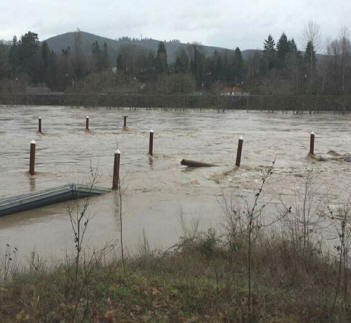
| Here you can see the log boom just above the rock burm | Here the second lower dock has not been installed yet | Here you see the area during the December 09, 2015 high water, looking upstream |
|
|
 |
 |
| Parking lot looking toward the tie down lanes and the ramp beyond. | |
 |
 |
Olequa Creek : Off I-5 at the Barnes Road exit, head west about 3 miles until you come to Imboden road. Follow it toward the river about 200 yards and and turn left on the Miekler Rd. to the boat ranch through the farming fields. There are no signs anywhere indicating a public launch. This launch is a concrete ramp at the junction of a large pool above with the Olequa Creek emptying in on the opposite shore. The concrete does not go quite far enough down to facilitate launching of some boats so some were launching on the gravel bar below (which now has been barricaded off as mentioned below).
This launch is one you will probably have to power load on as you can see in the photo below, as it sets broadside and close to the main current. However there is a small calmer pocket just upstream of the ramp that many pull into and tie up as they go for the trailer.
As of the fall of 2005, WDFW has set large concrete barriers with a sign restricting boat
launching off the gravel bar to protect spawning grounds and environmental
impacts. This was quite obvious to me as when I was there 09-18-05
there was a large Spring Chinook spawning red just off the shore in the exact
area the launchers frequented. Below that were many more smaller fresh reds.
There is a large gravel bar below the launch that plunkers
frequent. Many would drive down and park backed up toward the bank,
set watching the rods in the bank rod holders in bad weather before the barriers
were put in place.
However barricades have now been placed so driving on the gravel bar
is restricted. Fishing is still being done there, but no setting in the
car on the bar.
Some of the best Steelheading in the Lower Cowlitz is from the mouth of the Toutle down to Camelot.
To do this drift, launch at Olequa and take out at
Camelot if using a drift boat.
I-5 Bridge Launch :
Off
I-5 at the Barnes Road exit, head east and onto Jackson Highway heading north.
About 2 miles you need to turn left onto the Mandy Rd., down a hill and back under
the freeway bridge that crosses the Cowlitz River. The launch is located just
west of the I-5 bridge. Here is a single lane concrete ramp.
The earlier one adjacent to it downstream sanded in so
a new launch was installed the summer of 2004.
The water below it has
excellent plug, diver and bait slots downriver to "Pump House
Hole". However you would need a jet boat to make it beyond the
first big bend about a mile downstream. This is a high bluff deep corner
on the south side and a riffle above at the tailout of the long reach that is
visible from the launch. This area fishes best when the river is running below 7,500 cfs.
| Cowlitz I-5 Boat launch | |
|
|
Toledo :
In the town of Toledo is a
new boat launch. This has taken a while to get things together and the
project finalized. This project is supposed to be a 1/3rd shared funding
project with the city of Toledo.
To get to this launch follow State Highway 505 from I-5 east
to the town of Toledo. Go thru town and at the edge of town, just before you cross the highway
bridge, take a immediate right on Augustus street. The launch area is
immediately below the west end of the bridge.
It has a 2 lane poured
concrete boat launch
angling slightly downstream. It has a small parking lot to the right
before you get to the launch on Augustus street. The will be an overflow
parking area planned to the north across the highway.
It has restroom facilities and a handicapped bank fishing dock/platform upstream and adjacent to the ramp. However this is not used much, if you look at the location, with a high fishing platform area, no netting access, swift water out in front AND trees/log boom protecting the ramp, does not make for much of friendly access. Financing had come up short before completion so there will be a donation box for usage, with a fee of $5.00.
When these photos were taken 1-06-2010, the ramp itself was installed and usable, but the grounds were being worked on and yet to be completed.
| Toledo boat launch | Toledo launch area handicapped fishing dock |
|
|
|
Massy or Mission Bar :
From I-5 at exit 68, intersection of highway 12, go
east to the stop light,
turn left, (south) on Jackson Highway, turn left at the Toledo airport. Go
south on this road, cross Spencer road, then south onto the Buckley Rd. This is a
dead end road, and when you get there you might think it is a private road
going to the local homes, no public fishing or launch signs exist anywhere, but
at what appears to be the end of the road on the upper flat where the homes are,
just keep going straight, then veer a sharp right at the top, go down the hill. The road down to the ramp is crappy
but once you get to the bottom of the hill there's a huge parking lot and ramp
with restrooms. Here again you have some great plug/diver and bait water and
some good spots for throwing bobber and eggs from the bank also.
| Cowlitz Mission Bar launch | Here a boat is reloaded onto the trailer at Mission Bar |
|
|
|
Blue Creek Trout Hatchery :
From I-5 at exit 68, intersection of highway 12, go east about 8 miles turn
south on Brim Rd, and 3 miles to Spencer Rd. about 3/4 of a mile and left on the
Cowlitz Trout Hatchery Rd., follow to the public access and the hatchery complex.
It is the spot with the highest concentration of steelhead and fishermen and where 90% of the guides concentrate their efforts, it's a total zoo when the fish are in. Camping is allowed in certain areas next to the launch parking. There are restrooms and garbage cans here also.
It also has a designated
disability fishing access immediately downstream of the launch with a
concrete pad ramp down to the water's edge right next to the hatchery outlet
wier.
Word is that anything left in your car that is visible is up for grabs for the first thief to pass your door.
| Blue Creek Trout Hatchery launch |
|
|
Barrier Dam :
Go
east on Highway 12 from I-5 and as you enter Salkum turn right on the Fuller
Rd. Go south past the Barrier Dam Campground and tackle store to the
intersection of the Spencer Rd, turn left. Not far the road forks, straight ahead is dead end, turn right
and go down the hill to the
hatchery and barrier dam.
Go all the way
downriver past the bankie parking to the launch.
This launch is a
concrete slab ramp in a slightly protected cove. There is plenty of
paved parking. There is not much room
in the small pool below the ramp end (the pool is deep enough) but the pool
riffles out in shallow water when the river is low, (2500 CFPS) so the loading needs to come in at an angle
and then
onto the trailer, but doable for a jet sled.
In the RH photo above you will see remnants of the old
abandoned launch on the right.
There is a no boat fishing zone from the
ramp upriver to the deadline below the barrier dam. However a boat
can run upriver in this zone and drop off a bank angler.
This run down to the trout hatchery has a little of everything from deep holes to classic fly water.
Just about any method you fish you can find a spot to do it. Most all the guides that still pull plugs and have yet to given in to the boondogging
fish this area. If you put in at barrier dam area with a drift boat and plan
on taking out at the trout hatchery at Blue Creek, you can get a shuttle service
from The Barrier Dam Campground store.
For a drift boat, this area it is as close to having 6 miles of perfect drift water as anywhere on earth down to the Blue Creek launch. If you have a small motor for the drift boat, it will really help cover some of the less productive water.
Here is also a disability fishing ramp
directly above the launch.
| Cowlitz River Barrier Dam launch |
|
|
Copyright ©
2005 - 2020 5 LeeRoy Wisner All Rights Reserved
Back to the Main
Ramblings Page
Originated
9-18-05, Last Updated 10-26-2025 *
Contact the author