Lower Columbia
(Buoy 10) Salmon Fishery
 |
Lower Columbia (Buoy 10) Salmon Fishery |
 |
This fishery to
many, is on par with the Super Bowl for football fans.
Only here the fans
get to participate.
First Things First - Safety : Even though this fishery is inside the river, it is effected by the ocean conditions very close by, which can AND will become nasty at times. You need to have your boat in A1 condition so no problems arise that you can not remedy yourself and do it SOON. The Coast Guard Auxiliary and the US Power Squadron will inspect your boat for free. To find a flotilla near you CLICK HERE. This experience may just save your life and those aboard your boat. Test run your motor the night before. This should not be your first trip of the season as these will usually find the problems of a boat/motor being idle for a time as in winter layup.
If you have never been fishing there before, go with a fishing friend who has experience there, or preferably hire a guide. BE OBSERVANT OF EVERYTHING AROUND YOU. This is not an area for a 12 or 14' aluminum car topper boat.
The weather here can be very uncertain and you as a skipper will need to be able to call the shots ahead of time as to when you need to pull up the gear and head for the dock. When it gets rough, things happen, and do so FAST. When in rough water, even fishing line wrapped around the prop can be disastrous if there is enough of it and you mistakenly shut off the engine. It may restart, but not have the power at an idle to overpower the new resistance, not allowing the motor to be shifted into gear. Idling in neutral gets you no where. And this is not the place to have to motor all the way back to a dock on a kicker motor in 6' chop. BEEN THERE - DONE THAT, there on a very snotty day.
It can also get foggy. Do not go out without a hard mounted GPS and VHF. Backup hand-helds can also be handy if some of the electronics go bad. Also have a functioning anchor. Being swept to sea or onto the sand flats with the waves pounding you on the stern is not going to be fun.
When & Where You Can Fish :
It is common for WDFW and ODFW to open this fishery August 1st and close it near Labor Day, but the closure is very
dependent on the projected run, quota set
along with the actual total catch. The best fishing does not usually start on the opener, but picks up within a week or two, depending on the
weather and fish run size.
There is a agreement between the two states called shared jurisdiction. What this means is that a Washington angler can fish in a BOAT in Oregon waters,
and the other way around. You can also launch on either shore and fish, with either license. HOWEVER, you CANNOT bank fish on a shore that you are NOT licensed for.
Washington and now Oregon have fishing regulations in effect on the river as described by the new Oregon regulations. "Each angler aboard a vessel may continue to use angler gear until the daily limit of fish for all legally licensed
and juvenile anglers aboard has been achieved.
However no individual angler may exceed any personal daily bag limit".
As you can see in the chart below, the majority of fishing here will be in
Oregon waters.
| In the chart below, the buoy 10 north south line (yellow) is very close to the LH edge of the picture. Here the cream color areas are predominately Chinook, while the purple would be better areas later for Coho. |
 |
When to Fish :
The best tides to fish would be the low run-off tides or
the "Soft" tides being better. Early morning outgoing tides are good, where
you can fish the incoming tide which can be pretty good especially near high slack. It's the afternoon big outgoing tides that are
dangerous. Outgoing tide with the west wind, can be very interesting from a
small open boat on the ride back to the dock in the afternoon.
As said above, the best time to fish this area would be on a incoming tide on a low slack tide at early morning. Here the fish flush in on the incoming tide, following the bait.
Be there an hour early from the low tide, then troll downstream until you either get
to #10 or the tide turns. Look for bait or fish on the sonar. Then
troll with the current going upstream. Fish from Buoy 10 at the start of the incoming tide, slide upriver along a
rip, as the tide comes in. The fish may well follow the bait in and up the
river, so should you.
Fish from the Chinook entrance (marker #5) to the Washington side of
Astoria bridge up until and thru the high slack. You can then mooch back
the outgoing tide in 30' of water off the "Church". For the
Oregon boaters, the main shipping channel from buoy #20 up to #29 seem to be
productive.
On the other hand, if you are there, or that is the only time you can fish on a high morning tide, the game changes. Be above the Astoria bridge at daylight, and join the thousand or so boats fishing the "Blind Channel" which is a 35-40' slot nearer the Washington side that runs upriver for 3 or 4 miles. Troll downstream. Now if your timing is so that the you have to be there after the high tide slacks and the outgoing river water starts stacking up against what was there because of the high tide, creating rips that can get dangerous. These usually are near the WDOT rest area and south along the bridge. Then slide below the bridge and troll in the smaller fleet down to about Chinook, trying to stay about 1/2 way on the drop-off (35' or so).
There is not much going on during a rushing outgoing tide here. So if there is a lot of run-off (Like a 9.3 high followed by a -1.7 low) find somewhere else to fish or stay on the shore.
As a side note, if the fish and game departments restrict salmon to clipped fish, Rogue River stock (usually caught around Astoria) have a belly fin clipped, not the adipose fin. They can be tagged as a Hatchery Fish.
This fishery really gets into full swing about mid August. Chinook will be caught before that, but not limiting out by 9AM. After that date the Coho start moving in to step up the frenzy.
Here the limit is USUALLY one clipped Chinook and a Coho (either clipped or not, but determined by the timing).
Weather Conditions :
The weather here can at times be windy and therefore choppy enough that the average small boater should be very observant. If you are on the middle of the river
and the wind comes up, it will behoove you to move closer to your launch point before it gets dangerously rough.
The wind typically picks up between 1:00 and 3:00pm and depending on the tide,
especially if it is in the middle of an outgoing tide, there WILL be chop on the water when you head back if you launch at any of the first two launches listed below. With a smaller or an open boat you WILL get wet. This wind usually dies down later in the evening, usually around 7:00 PM.
A deep 18í boat would be considered MINIMAL, and it should be mandatory operational bilge pump and a fully functioning kicker motor be attached
and ready.
A
convertible top can be a of a help if you are running with any chop on the water.
A VHF radio would be mandatory.
Water Conditions :
This is a large river with LOTS of water moving during any exchange. A small skipper miscalculation or
inattention for a moment could be deadly. It is prudent to have all on board wear a
Personal
Floatation
Devise. The new suspender inflatable type are becoming more popular since the Coast Guard has now approved them, (if being worn).
Combating Wind : Given that most of your fishing here will be trolling, there may be a time when you need to be heading into the wind and in this location where you can be restricted in where you need to go because of other boat traffic or the bottom and water conditions, you might consider having a drift sock available. OK, these is usually used for anchoring, but! Hang your drift sock off the bow on the side of the boat the wind is hitting you. If this isn't enough, then hang a second sock half or two thirds back on the same side. It will help keep keep you straighter. It will not be perfect, but helps a lot. If its still isn't enough then call it a day because its too damn windy.
Mother Nature : At times, like 2022, things may change dramatically. Here, during the month of August, the water temperature was warm, like 66 to 70 degrees, rather warm for fish who like it more in the mid 50s. And in addition, there was NO bait (anchovy or herring in the river). This then is a major game changer as normally the salmon that would enter the river here, follow the food chain into the river by the incoming tide.
Or glorious WDFW had predicted a pretty darn good salmon return this year, but they will now probably tell you the problem is because of Ocean Conditions. Could it be because of over harvest by the sardine seiners? Do the ones who issue those permits even talk to the fish managers for salmon?
If you talk to the larger sport boats, they are pulling a good salmon catch, BUT they are running out to 350' of water and fishing 200' deep, apparently to get into cooler water that the bait/salmon prefer.
The question is, are there are no salmon
in close because the bait has been depleted, OR the salmon run was just a
paper estimate?
Commercial Vessel Traffic :
One thing to keep in mind is that this whole river (except the Washington
side from Chinook upriver, under the bridge and to
Portuguese Point) is a means of commercial water travel for many different types of vessels, including ocean going ships
and tugs. The normal shipping lane depths may be dredged and kept at a minimum of 40 ft
at low tide. Some ships may be coming in at any time of tide but upriver
and downriver traffic can increase during the high tide.
And consider that if they are going out with the tide, which means they have very
little steerage as the current is doing a lot of pushing. These shipping lanes are just like a highway, with upriver designated for the Oregon side,
and downriver designated for the Washington side of the
shipping lane.
If you as a small boater plan on fishing near these shipping lanes, it may be a good idea to become familiar with the US Coast Guard "Rules of the Road" as far as who has right of way
and the boat whistles governing them.
If you conclude that they are larger than you and may not even see you, so leave
them lost of room will be a good lesson learned.
Also the Coast Guard will come channel 16 warning recreational boats that a ship will be passing by and reminding them of the rules. You may even hear a ship sound 5 short blasts of it's horn. This is in reality a warning, as it means "I do not understand your actions".
Also if it is foggy and you happen to be in the shipping channel (whether you know it or not) and encounter a large tug boat moving up or downstream in your area. STOP, wait for a few minutes after it passes as it may well have a barge in tow that you can not see. And towed barges make no noise. If you decide to run behind the tug and over the tow lines, this may be hazardous to your health and undoubtedly disastrous to your boat/motor. And if it is that foggy the tug may never know you are there or in trouble, not that he could really do anything anyway.
| Here an inbound freighter is coming in the channel just upriver from the buoy 10, as the recreational boats are fishing |
|
|
Method of Fishing : Most of this salmon fishing will be done trolling divers or using dropper sinker lines with five foot leaders to your favorite lure behind Fish Flashs, bait (herring or anchovy) or spinners, and run them out from 20 to 45 feet on your line counters, or figure out how many pulls that is (at 2' per pull). The line-counter reels are a plus here. The use of a Fish Flash no-drag flasher has now become widespread. When using a Fish Flash, or it's equivalent behind a diver, some connect the diver directly to the Fish Flash, but I have found it works best for me to tie a short length of line (12" to 16") between the diver and the Fish Flash to allow it to get out of the diverís turbulence so that the Flash will rotate properly.
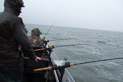
With the tide, current and close combat fishing at times, it is best to NOT run light weights or a long distance back. Here, you want the lines almost directly under the boat (which also gives the skipper some maneuverability). To accomplish this, the front fisherperson uses heavier sinker (possibly 16 to 20 oz.) and longer rods along with shorter distance out. The next rod rearward will use a slightly lighter weight, and slightly shorter rod and a bit shorter distance out (like 2'). What this does is help prevent tangles in lines. It also allows you to cover more fishable water. The stern rods line can be farther out yet, and possibly a lighter sinker. You also want to use heavier line/leader (40# leader at the minimum) to be able to bring those fish in a soon as possible, otherwise you may loose your fish to sea lions.
|
Seen here, you can see the heavy weight on the rod tips & the stern (shippers) rod |
 |
The best fishing is in water between 12-40 feet deep. It is best to have a GPS and a Fish finder, find the bait balls and stay on it. In the mix, it is good if you locate bait on your depth finder and try to stay near it. If you don't, watch the birds or follow the fishing guides. If you have more than 1 rod, put different bait/lures on each rod, fish each rod at different pulls out (depths). It just comes down to putting the lure down in the zone, or where the rod that is that hot rod's depth is set at. Consider changing the other rods near that hot rod's depth once you dial into the zone. If you make 2-3 passes in an area and you're not hitting fish, MOVE. Don't be intimidated by the crowds, as some of the best fishing will be bumper boats all trolling in UNISON (like a larger dance floor). If that gets on your nerves, then move away to find your own fish.
As the tide starts to come in, cooler ocean water will be pushing in against the warmer river water. The fish will be moving upriver with that incoming salt water. This ocean water salt water, being heavier will be under the freshwater. This water could be pushing considerably faster than what you see on the surface. The depth dividing line between the two waters is where you want your lure to be or below it. You may have to turn up the sensitivity "gain" on your depth finder to be able to see this line.
Now for something else to think about, these fish will not be swimming upstream, but will be headed downstream, but allowing the current to push them upstream. Here is where you want to back troll, which will be starting low on the river, (B 10 or near), head the boat downriver but run your trolling motor just enough so you will be slipping upstream. In doing this, your boat will be moving upriver slower than the fish will be carried by the current. They then will have more time to see your lure than if you were whizzing by trolling WITH the current.
Keep on the look-out for other close boats, wakes, and swells. It's very easy to get excited when someone is fighting a fish, so do not rely on the other boat to be watching where they are going all the time if this is happening. Watch what is happening in your boat, when you get a fish to the boat, make every effort to keep everyone from leaning to one side watching the fight. Big mistake, as one big wake from a passing boat or swell, can knock someone over board. It is a good idea to have one person watch for incoming boats or huge wakes/swells. The person netting is usually the one that is more likely to fall overboard as they are focusing all their attention on netting the fish, possibly even leaning over too far to in order to scoop that fish in. Always wear your PFDs here.
The common signal to other fishermen that you are fighting a fish is for one person to stand up with the landing net also pointing up. This usually is the sign for other boats to give you some room if you have a big fish on that is not cooperating. On the other hand, there is no need to do this if the fish is small or has had it's mind changed and is coming in. The other problem is that this flag waving many times will attract other fishermen who have not had the good luck as you, so you may soon have some new neighbors including seals/sea lions.
For Chinook, you would normally want to have the lure NEAR the bottom.
If you try this with a diver, you run the chance of getting hung up and at least
damaging the herring by dragging it on the bottom. Here is the place to
also use the estuary set up of using a sliding dropper about 16"-20" to a
10oz to12oz,
cannonball sinker, which usually allows the lure to be just above the bottom.
An Apex plug in chrome, blue prism/chrome or a Coyote spoon in cop car color
(black and white), or glo in the dark green/white can also be very productive here using the diver.
The recent introduction of then Brads Super Cut Plug has also proven a very good
lure, especially when loaded the cavity with squashed herring or anchovy, even
using a scent paste helps.
It is advised to NOT use a downrigger if you are fishing an area that is in the heavy concentration of boats because of potential tangles with other fishermen, especially when everyone is close. Mooching a cut-plug herring is of course another viable method practiced by some but do not do in in the bumper boat parade as you will be moving at a different rate of speed as the others and could create a line tangle problem.
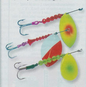
Some of those who fish this area a lot have found that using spinners do very good (especially if the water is warmish). Using a diver or a cannon-ball on a dropper, trolling large #5 to #7 spinner can be effective at times. The larger size proves more productive for Chinook. Different blade designs make a difference in how they spin. The Colorado blade which is more rounded spins at a slower speed or current. The Willow Leaf style blade needs a faster speed or current , while the Cascade style is a combination of the two and can be used in about any situation.
Try different colors of spinner blades as what is
doing fine one day may not be effective the next. However the traditional
white with a diagonal red lower end catches a lot of fish. Recently just
to do something different, one lure maker painted the back of a blade black. The results were
phenomenal. Many times if you are not getting a hit, use a felt marker,
paint a large black eye on the outside of the blade. Also do not hesitate
to add a pink or orange hoochie skirt to the rear of your spinner.
Most of these spinners will come with a triple hook attached. Some have a
plastic sleeve over the hook's eye and the rear of the spinner shaft. The
theory here is to keep the hook straight. However you may see some using
single Siwash hooks or even doubles .
Most accomplished spinner fishermen here use a heavy leader 6' long.
However since most commercial spinners are not made using a barrel swivel on the
front, so these fishermen add a 6 bead chain swivel midpoint in their 6' leader. Use a heavy leader, from 40# to 50#
as these fish are not leader shy.
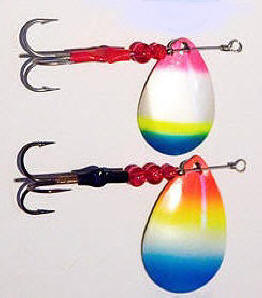
In the photo below, the 2nd from the left has a hole drilled in the rear of the blade, which adds air bubbles and extra noise. All of the ones below were custom made.
| Here are a few different favorite salmon spinners |
|
|
The spinner shown below is also the one on the right above, which started out life as a hammered brass blade. The whole outside of the blade was initially painted white. The black sided blade was accomplished by lightly spraying the black color just enough to make it black. When it dried, because of the hammered brass design and the translucent chartreuse 8mm beads, when the sunlight hits it you will see the many facets of the hammered brass individually reflect the color.
| This is the spinner on the right above but with the back side of the blade painted black | Same spinner as on the left but positioned so sunlight is reflecting off beads |
|
|
|
| Other favorites | Rainbow colors |
 |
 |
Late in the season, when Coho move upriver, the water temperature may be in
the 63 degree plus range, they are seen in schools with your sonar, but have
lockjaw for normal fishing methods, one thing to try is to use a lead jig like
the Buzz Bombs or Point Wilson darts.
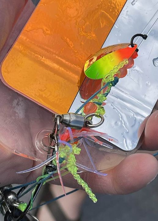
Shown below is the result in letting your line out to fast.
| Here is a tangle superme |
 |
Where to Fish :
This
Buoy 10 fishery is is somewhat more akin to fishing the ocean than the up river
fishing most people are used to. The best advise for a newbie would to
forget about fishing spots. The fish will be where the bait fish are and
the bait fish do move. Hungry salmon aren't just going to be hanging out
in 20' of water 200 yards west of the bridge at noon on a Friday just because
that is where you caught them last year. The salmon are going to be
crashing big bait balls to fill up their belly's before that long journey up
river.
Don't waste a bunch of time fishing a "spot" if there
isn't bait, move until you find bait. As a general rule, find diving
birds, rip seams, and/or bait, and you will find salmon.
The boundaries for this fishery are illustrated by the yellow lines on both of the charts shown. Fishing close to Buoy 10, sometimes called the "Firing Line" can be called "Combat Fishery", meaning the boats will be maneuvering, trolling/mooching in close proximity to each other, where some boat operators do not watch where they are going. Charter boats seem to tend to squeeze the sport boats, with their rods almost touching the smaller boats. Others boaters may seem to not be aware of what is going on around them, as when a big fish is being played within 20' of their boat. This can be compared to a large dance with MOST of the boats all hopefully going the same large circle AND close to each other.
You will see some boats, when running back to their start position for another pass come so close to other boats (and rocking them, especially bad if they have a fish on) making things dangerous. If they would have moved two boats to one side, everyone would have had room to spare. Tunnel Vision. Others will be trolling parallel with you and then when their stern is at your bow, cut in front of you as if they were a Kenworth tractor/trailer and bigger than you, and you have to put it in reverse ASAP or hit them. They just keep looking forward as if they did nothing wrong. For these I keep a Freon horn handy. Some even will not give an inch when fighting a fish, (maybe running on a TR-1 auto pilot) even to the point of tangling lines, and then of course, it is your fault.
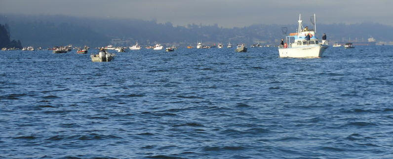
Occasionally a blind (a Mr. I own the river) operator may want to troll across thru the trollers or a mooching dance floor, which may even get more than under the breath exclamations toward him. It is not uncommon to look out and see 300+ boats in an area of 1/2 mile. One thing, if anyone fell overboard, they would not be in the water over a few minutes.
| Here is a typical view of the river when the fish are in |
 |
Most salmon fishing early in the season will be near Buoy 10 at low incoming tide, some prefer just north
near buoy 11, while others prefer near or south of buoy 10. This
area is portrayed as a cream color on the chart shown above. When fishing for Chinook early in the season, a trend is to be at
buoy 10 at low incoming tide and allow the tide to carry you upriver along the Oregon side,
(buoy 12) sliding across and over to the Washington side just above Chinook.
Again in the cream chart color, there seems to be good bait holding spots off the breakwater piling
#1, #3, and #5 on the Washington side near both Big and Little Sand Islands
and up to the Chinook entrance on the high ebb.
When the Coho are in, they of course will be intercepted first at the buoy 10 "Firing Line", then they follow a rip upriver as the tide comes in.
The better Coho areas are portrayed in purple color on the above chart.
Later on in the tide and or season, the fish seem to congregate near the northern end of the
Astoria/Megler bridge.
The worst, as far as concentration of boats, will be near Buoy #10, which is the westernmost WDFW
/ODFW boundary and the first shot at these returning fish. It seems to be human nature to be there at the starting gates when the gun goes off.
The jetties' shore ends, would be about between buoy #11 on the north and buoy #12 on the south. Buoy #10 is located about 1 mile outside or west of these two buoys.
This area, however, seems to be one of the best locations to fill a limit.
Most of the charter boats will work this area.
Many people will bypass the buoy area and fish upriver near the middle of the river and near where the the
old "Yellow Can" (D) buoy, 46-14-40 123-57-30, used to be, (they have removed it
years ago). It still shows on some older charts, which designates a dredge dumping area and is in 25-30'. It is about 1/2 mile off the breakwater near the town of Chinook entrance.
There is also a 50'/60' slot at the "Church Hole" which is between the Chinook entrance
and upriver to the bridge on the Washington side, where many Chinook salmon are taken.
There is a old church on the Washington shore that is right on the shore with it's
high steeple is very visible, hence the name.
The charts may only say "Spire" on the shore in this location. The other area where many fish are taken is again from the church to the bridge but farther away from shore in the 30'
slot just downstream of the bridge where the high bridge spans meet the lower piling spans.
Some nice Chinook have been pulled by back bouncing a herring along the bottom thru this Church Hole slot on an outgoing tide.
| Here the lady has a nice Chinook on --note the edge of the church in the background on shore at the left |
|
|
As the tide nears and goes into high slack, the fish
(especially Coho) seem to congregate above the bridge and up to the WDOT rest area
out to the south in shallow water above the bridge.
There seems to be an imaginary line from the Washington side high spanned section of the bridge to Tongue Point that the upriver salmon seem to follow and cross over the shallows at high tide to the main channel on the Oregon side. The few
fish that stay near the Washington shore in the upper end of the bay, will probably be Deep River or Grays River fish.
The river's deeper channel splits at about the Chinook entrance. It is wide
and deep enough at this area that many fishermen do not realize this split takes place. The main shipping channel follows the Oregon shore up past Astoria, Tongue Point
and on east of Rice Island, then onward toward Cathlamet. The center of the river below
and above the bridge are dotted with sand spits at low tide
which are not normally navigateable.
The deeper water on the Washington side terminates above the bridge above the WDOT rest area
near the shipwreck. This channel is sometimes called the "Blind Channel",
and it then runs upriver toward Portuguese Point
and then on into the shallow non navigateable bay at the mouth of Deep River and Grays River.
|
Here, above the rest area on the Washington side is a landmark known as the shipwreck |
|
|
Method of Fishing :
Most of this salmon fishing will be done trolling
divers or using dropper sinker lines with five foot leaders to your favorite lure
behind Fish Flashs, bait
(herring or anchovy) or spinners, and
run them out from 20 to 45 feet on your line counters, or figure out how many pulls
that is (at 2' per pull). The line-counter reels are a plus here. The use of a Fish
Flash no-drag flasher has now become widespread. When using a Fish
Flash, or it's equivalent behind a diver, some connect the diver directly to the
Fish Flash, but I have found it works best for me to tie a short length of line (12"
to 16") between the diver and the Fish Flash to allow it to get out of the diverís turbulence so that the Flash will rotate properly.
In recent years, the 360 flasher has become popular. This is a plastic version of the old Abe & Al flasher. Also some of these have an E-Chip fastened to the front of the blade along with a "Kicker fin". Then more invention came along and a lighted blinking light mounted in the middle of this flasher. Here, you really need to run the heavier sinkers.
With the tide, current and close combat fishing at times, it is best to NOT run light weights or a long distance back. Here, you want the lines almost directly under the boat (which also gives the skipper some maneuverability). To accomplish this, the front fisherperson uses heavier sinker (possibly 16 to 20 oz.) and longer rods along with shorter distance out. The next rod rearward will use a slightly lighter weight, and slightly shorter rod and a bit shorter distance out (like 2'). What this does is help prevent tangles in lines. It also allows you to cover more fishable water. The stern rods line can be farther out yet, and possibly a lighter sinker. You also want to use heavier line/leader (40# leader at the minimum) to be able to bring those fish in a soon as possible, otherwise you may loose your fish to sea lions.
|
Seen here, you can see the heavy weight on the rod tips & the stern (shippers) rod |
The water temperature recorded at Bonneville Dam this time of the year usually will be 70 to 72 degrees, but on the incoming tide at Illwaco, the cooler (56 degree) ocean water will come in
and back upriver on the high tide, cooling the river water to below 60. As the tide turns and starts running back out the temperature will raise to about 62-65 degrees. Once the fish move above this cooler water where there isn't the cooler salt mix, this is really warmer for them to comfortably stay in. So the early fall
Chinook above this estuary will more than likely then be found in the deeper holes or at the mouths of the rivers dumping into the Columbia.
Boat Launches in the Area:
There are many launches on both the Washington and Oregon side of the river in this
vicinity. On the above chart they are shown is light green. (NOTE)
prices here may be obsolete
(1) Illwaco:: Port of Illwaco 165 Howerton Ave., Illwaco, WA 98624 360-642-3143
$5.00
(2) Fort Canby:: (State Park)
$5.00
(3) Chinook:: Port of Chinook 1 Portland St., Chinook, WA 98614 360-777-8797
$5.00
(4) Deep River:: Onieda Rd., Naselle, WA 98638
free WDFW
(5) Cathlamet:: Elochoman Marina P.O. Box 651, Cathlamet, WA 98612 360-795-3501
$5.00
(6) Hammond:: Hammond Marina 1099 Iredale St., Hammond, OR 97121 503-861-319
$5.00
with a parking fee of $5.00
(7) Warrenton:: Warrenton Marina 550 NE Harbor Pl., Warrenton, OR 97146 503-861-3822,
harbormaster's cell 503-791-1925 launch fee $5.00
(8) Skipanon Marina:: Skipanon Marina 200 NE Skipanon Drive, Warrenton, OR 97146 503-861-0362
(9) Youngs bay Yacht Club:: Youngs Bay Park Astoria, OR 503-325-7275
free
(10) John Day River (Tongue Pt) (county launch) $3.00
(Note, some of these prices may have changed
(likely doubled) since this survey
was put together 6-2008)
The launch at Illwaco is off the main road into town just after you drop down off the hill, take a left at the sign that says launching ramp. If you miss that, then just go to the stop light, turn left and the frontage road at the dock area, follow it to the eastern end
and around the boat basin to the launch on the south east side. There is a nice new two lane ramp, also a sling,
and with lots of paved parking along with long term trailer parking.
For Fort Canby, you have to go west thru the town of Illwaco, at the stop light, west
and south, then back east, winding thru the park then down to the ramp. The State Parks is planning to improve this launch in the early summer of
2004. The plans are to install a 3rd lane and to increase parking.
The Chinook launch is off Portland Street. It has a new concrete ramp and a sling,
parking has been expanded to the south on some of the old dredging spoils and some overflow is along the streets
at peak times. Also the channel out of the Chinook harbor is
NARROW, but it has a 55 gallon barrel marking both edges and then piling marking
the rest of the way. It was re-dredged mid September of 2015, so navigating out of here for the small boat
should be a lot better. HOWEVER on returning, and as you get near
the actual basin channel, DO NOT CUT THE CORNER SHORT, but go to the left of the
entrance marker.
The launch line here is as you enter off Portland
street, as you enter the parking/activity area, hang a right and go NW up and
around the fish cleaning building, take a left near the lift, and then another
left heading SE parallel to the shore to prep lane for the launch.
Bait :
Bait is available at both Illwaco or Chinook thru Ed's bait. The Illwaco location is open at 5:00AM
and is on a dock that is close to the launch area. The Chinook location is Jack Marsh, Cracker Box
Bait being on the main road in town highway 101 and Olympia street, which is the
next street south of Portland Street, which is also the secondary entrance to the Chinook boat launch.
Gas : The fuel dock at Illwaco is just north of the launch ramp and sling. The Chinook fuel dock is close to the launch and port office, but for a small boat owner, the fuel flow is excessive and you will need to throttle back on the lever. And they now do take credit cards to pay for the fuel.
Other Activities :
Here, if launching from Illwaco or Chinook, some will
drop crab pots off inside Baker Bay, or inside the North Jetty on the way
out and pull them on the return trip. Also, "A" jetty has been
rebuilt within the last few years, it can provide easy, and safe access to
fishing for sea bass.
The Other Alternative is Deep River:
It takes about 30 minutes for the average boat to run from this launch downriver to the Astoria bridge. This launch is located off State Highway 4 between Naselle
and Cathlamet.
For info on this location
CLICK HERE
Miscl. :
Numerous motels, RV parks, gas
and accommodations are available at Illwaco or just north into Seaview and the Long Beach peninsula. Others are West into the town of Chinook.
Usually the RV and motel accommodations are booked solid for week-ends many months
ahead during this season.
There are restaurants or cafes and motels in Ilwaco, Seaview, Chinook, Naselle
and at of course a Mini Market or two.
For those of you who have communication radios in board, VHF channel 68, 69 or
72, with CB channel 6 or 10 seem to be the chatter channels.
Copyright © 2004 - 2025 LeeRoy Wisner All Rights Reserved
Back to the Main Ramblings Page
Originated 10-22-2004 last updated 02-20-2025*
Contact the author